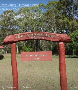
The former Ventnor State School is located on Yarrol Road in Ventnor. The site consists of a one-room school building with verandah, a play shed, a girls’ and boys’ toilet, remnants of an old swing post and a flagpole.
The School was heritage-listed on the 21 October 1992 and was built in 1914. Originally constructed as an open-air school in Maryborough, the school was originally located at Teddington Road, Tinana and opened at the end of the same year.
As an open-air structure, the school was one of the experimental designs for state primary schools instigated by the Queensland State Government as a response to the advocacy that suggested maximum ventilation was necessary for a school building and optimal learning. These designs were only a government focus for a short period and did not become a permanent feature of educational architecture. By 1922 the open-air school design was phased out and more traditional designs reappeared.
In 1929 the building was transported Wongalee with school commencing in September of that same year. It is likely that the school was enclosed in 1932 when permission was granted for the construction of a play shed, along with the addition of a skillion-roofed verandah.
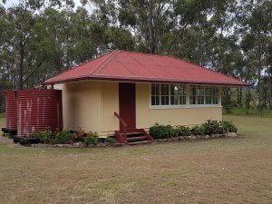
In 1945 an application was made for a school in the Yarrol Road area. Tim Maloney, then owner of portion 111, donated three acres to the Queensland Government as the site for the new school. The school building was once again moved and transported to its present site and classes commenced classes on 3 June 1946 with Doreen Turner as teacher. The school continued operation for 14 years until 1960 when it was closed due to low enrolment numbers.
In 1963, local residents offered £150 to purchase the school from the Department of Education and the ownership was transferred to the Ventnor Progress Association in March.
Since 1963 the property has been used as headquarters for the progress association, for religious and community groups and was as a polling booth. The Ventnor Progress Association continues to own and maintain the premises.
Visit The Ventnor School
(Approx 73kms)
- Take a picturesque drive through the Cannindah, Yarrol and Bancroft areas and visit this amazingly well kept school with a fascinating history on display.
- Depart the Monto Post Office in a southerly direction towards Mulgildie for 6.7kms. Just past the grain silos there is a turn to the left onto Yarrol Rd.